Open your mind, your heart to other cultures
Abra su mente, su corazón a otras culturas
You will be a better person
Usted será una mejor persona
RM
Abra su mente, su corazón a otras culturas
You will be a better person
Usted será una mejor persona
RM
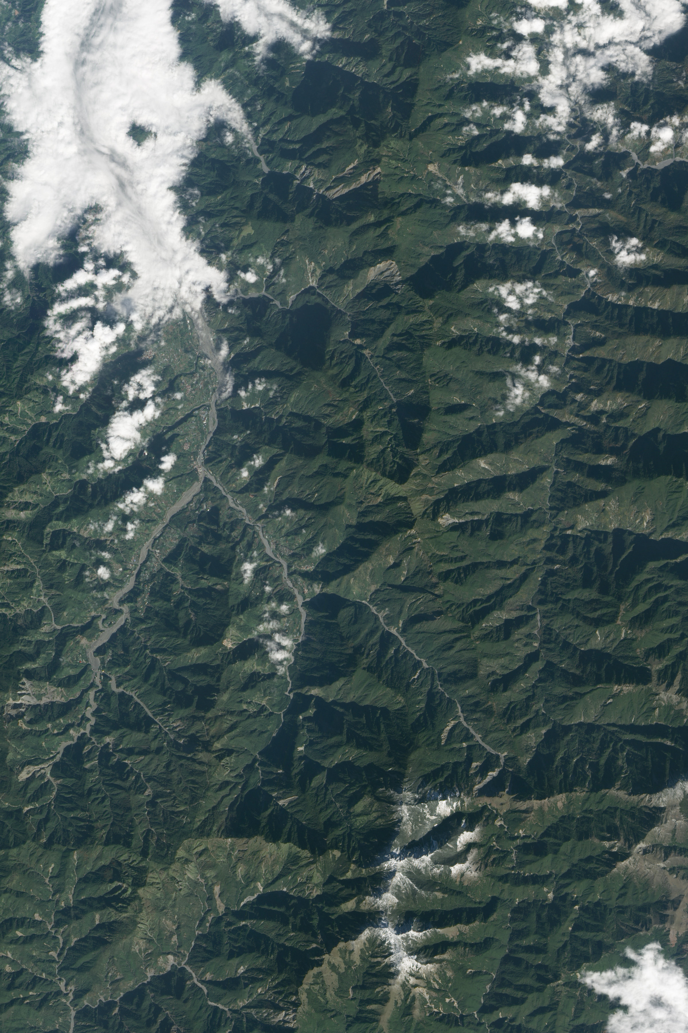
acquired December 17, 2010
Taiwan is a mountainous, seismically active island. In fact, mountains account for about one-third of Taiwan’s land area, with a range stretching in a rough north-south line down the center of the island. Those mountains comprise the island’s main watershed, and water is plentiful thanks to ocean currents and breezes that deliver warm, moist air, periodic monsoon rains, and several typhoons each year.
The rugged topography and abundant water make for well-vegetated mountains, but this combination also leads to landslides. On December 17, 2010, the Advanced Land Imager (ALI) on NASA’s Earth Observing-1 (EO-1) captured this natural-color image of landslide-scarred mountains in central Taiwan.
As a professor of geography at Durham University (U.K.), David Petley has tracked numerous landslides in Taiwan, including a large one that struck northern Taiwan in April 2010 (beyond the area shown above). Petley notes that typhoons frequently ravage the region and cause flash floods and landslides. Typhoon Morakot and Typhoon Megi are two recent examples.
“The passage of typhoons past or across Taiwan often leads to the generation of exceptionally high rainfall totals,“ he notes. ”When combined with the steep topography and weak rocks, the rain inevitably triggers extensive landsliding.” Some landslide mitigation methods include mountain braces, such as those employed in Chiayi County.
References
- CIA World Factbook. (2011, May 26). Taiwan. Accessed June 9, 2011.
- Geography of Taiwan (2001). Summary. Accessed June 8, 2011.
- Petley, D. (2009, August 12). Taiwan mudslides — a very lucky escape for most. Dave’s Landslide Blog. Accessed June 9, 2011.
- Petley, D. (2010, October 24). Landslides from typhoon Megi in Taiwan. Dave’s Landslide Blog. Accessed June 9, 2011.
- Taiwan Water Resources Agency. Topography of Taiwan. Accessed June 8, 2011.
NASA Earth Observatory image created by Jesse Allen and Robert Simmon, using EO-1 ALI data provided courtesy of the NASA EO-1 team. Caption by Michon Scott.
- Instrument:
- EO-1 - ALI
NASA: Taiwan - Landslide Scars in Taiwan - Cicatrices de los deslizamientos de suelo en Taiwan
You have an alphabetical guide in the foot of the page in the blog: solitary dog sculptor
In the blog: Solitary Dog Sculptor I, the alphabetical guide is on the right side of the page
Thanks
Usted tiene una guía alfabética al pie de la página en el blog: solitary dog sculptor
En el blog: Solitary Dog Sculptor I, la guia alfabética está en el costado derecho de la página
Gracias
Ricardo M Marcenaro - Facebook
Blogs in operation of The Solitary Dog:
solitary dog sculptor:
http://byricardomarcenaro.blogspot.com
Solitary Dog Sculptor I:
http://byricardomarcenaroi.blogspot.com
Para:
comunicarse conmigo,
enviar materiales para publicar,
propuestas comerciales:
marcenaroescultor@gmail.com
For:
contact me,
submit materials for publication,
commercial proposals:
marcenaroescultor@gmail.com
Diario La Nación
Argentina
Cuenta Comentarista en el Foro:
Capiscum
My blogs are an open house to all cultures, religions and countries. Be a follower if you like it, with this action you are building a new culture of tolerance, open mind and heart for peace, love and human respect.
Thanks :)
Mis blogs son una casa abierta a todas las culturas, religiones y países. Se un seguidor si quieres, con esta acción usted está construyendo una nueva cultura de la tolerancia, la mente y el corazón abiertos para la paz, el amor y el respeto humano.
Gracias :)

No hay comentarios:
Publicar un comentario