Click the photo to enlarge it

acquired May 23, 2012
download large image (837 KB, JPEG, 3800x2800)
acquired May 23, 2012
download GeoTIFF file (14 MB, TIFF)
acquired May 23, 2012
download Google Earth file (KMZ)
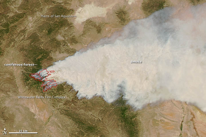
Wildfire season is in full swing in the southwestern region of the United States. The image above shows the Whitewater-Baldy Fire Complex, a large blaze burning in a mountainous part of Gila National Forest
in western New Mexico. The rapidly expanding fire, which started with a
lightning strike, had burned more than 10,000 acres (16 square miles)
by May 24, 2012. The Moderate Resolution Imaging Spectroradiometer (MODIS) on NASA’s Aqua satellite acquired the image at 2:40 p.m. local time (20:40 UTC) on May 23, 2012.
Desert grasslands and scrub forests (tan) dominate the lower elevations at Gila, but at higher elevations coniferous forests (green) full of white fir, blue spruce, and Douglas fir thrive. The amount of smoke the fire released increased as it encountered the coniferous forests at high elevations. When MODIS captured this image, the fire was burning through a densely-forested area around Willow Mountain, a 3,280-meter (10,760-foot) peak in the Mogollon Mountains. The Plains of San Agustin, a dried lake bed with minimal vegetation, is also visible near the top of the image. The plain is home to a world-famous radio telescope facility used by astronomers called the Very Large Array.
Strong winds pushed wildfire smoke across much of southwestern New Mexico. The area is sparsely populated, but on May 22, 2012, authorities ordered a precautionary evacuation of Willow Creek, a campground and summer community just north of the fire. Two days later, the fire had destroyed twelve summer homes and seven outbuildings at Willow Creek. Strong winds and rugged terrain have proven significant obstacles for crews attempting to fight the blaze.
Drought put much of New Mexico and Arizona at risk of wildfire. The National Center for Drought Mitigation produces daily maps based in part on data from the Gravity Recovery and Climate Experiment (GRACE) that indicated more than half of New Mexico was in the midst of severe or moderate drought. Numerous other large fires have burned recently in Arizona.
The rest of the 2012 fire season in the Southwest will likely be busy, according to the Climate Prediction Center at the National Oceanic and Atmospheric Administration. As Climate Central noted, the region is expected to face an unusually hot and dry summer due to back-to-back La Niña events in the South Pacific.
While the fire season in the Southeast has gotten off to an early start, the total number of fires and acreage burned nationally to date is below average, according to statistics from the National Interagency Fire Center (NIFC). However, the group notes there’s a higher than normal risk that large fires will occur in eastern Arizona and western New Mexico through August.
References
- InciWeb. (2012). Baldy Fire. Accessed May 24, 2012.
- InciWeb. (2012). White water Fire. Accessed May 24, 2012.
- Keane, Robert. (2000). Mapping Vegetation and Fuels For Fire Management on the Gila National Forest Complex, New Mexico. USDA Forest Service.
- Climate Central (2012). Western U.S. Faces "Extreme" Wildfire Risk Now and Later. Accessed May 24, 2012.
- National Interagency Fire Center. (2012). Western U.S. Faces "Wildland Fire Outlook May Through August 2012 (pdf). Accessed May 24, 2012.
- Silver City Sun-News. (2012). Smoke from Fires in Gila Affecting All of Southwestern New Mexico. Accessed May 24, 2012.
- InciWeb. (2012).
NASA image courtesy Jeff Schmaltz, MODIS Rapid Response Team, Goddard Space Flight Center. Caption by Adam Voiland.
- Instrument:
- Aqua - MODIS

No hay comentarios:
Publicar un comentario