Click the photo to enlarge it
Click sobre la foto para agrandarla
acquired May 26, 2012
download large image (4 MB, JPEG, 3600x2400)
acquired May 26, 2012
download GeoTIFF file (16 MB, TIFF)
The Okavango Delta
is an oasis in Africa’s Kalahari Desert. When the Kalahari reaches its
driest phase—when plants wither and animals hunt for drinking water—the
Okavango provides it. But starting in 2009, the delta provided more than
usual, and excess water overflowed into other land depressions in the
region.
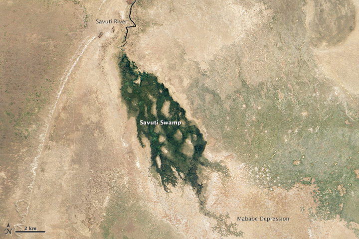
One of the waterways linked to the Okavango Delta is the Savuti River, roughly 80 kilometers (50 miles) northeast of the sprawling inland delta. On May 26, 2012, the Advanced Land Imager (ALI) on NASA’s Earth Observing-1 (EO-1) satellite captured this natural-color image of water flowing through the Savuti River and into Savuti Swamp. The swamp sits inside the larger Mababe Depression within Botswana’s Chobe National Park.
Unlike the seasonal flooding that affects the Okavango Delta every year, the flooding in 2012 was unusual. Guido van Langenhove of Hydrological Services Namibia characterized it as “an exceptional hyrological event.”
The rains that fill the Okavango don’t actually fall over the delta itself. Instead, the rains fall in the Angolan Highlands and travel about 450 kilometers (280 miles) through meandering rivers and over an extremely shallow gradient. As a result, rains that typically fall over Angola from October through March don’t usually reach the bottom of the Okavango Delta until July. But in May 2012, water had already arrived in the Okavango and was overflowing into other waterways such as the Savuti River.
“The Okavango Delta has had record floods for a few years now,” said Frank Eckardt of the University of Cape Town. “We have seen the Boteti River in flood since 2009, and have also seen water in Lake Xau, southeast of the delta. Now we are seeing water in the Selinda Channel, heading into the Mababe Depression northeast of the delta. Some of these depressions only fill with water after decades of dryness.”
Van Langenhove concurs, remarking that the flooding had reactivated waterways in the region regarded by some observers as “fossil rivers.”
Related Resources
- BirdLife Botswana. (2009, September 22) Will Lake Xau fill? Accessed June 4, 2012.
- Burrough, S.L., Thomas, D.S.G. (2008) Late Quaternary lake-level fluctuations in the Mababe Depression: Middle Kalahari palaeolakes and the role of Zambezi inflows. Quaternary Research, 69(3), 388–403.
- Global Flood Detection System – Version 2. (2012) Selinda Channel. Accessed June 4, 2012.
- Okavango-Delta.net. Okavango Delta Information. Accessed June 4, 2012.
Links
Chobe National Park. Botswana Tourism.
- Okavango Delta. NASA Earth Observatory.
- Boteti River, Botswana. NASA Earth Observatory.
NASA Earth Observatory image by Jesse Allen and Robert Simmon, using EO-1 ALI data provided courtesy of the NASA EO-1 team.
Caption by Michon Scott with information from Frank Eckardt, University
of Cape Town; and Guido van Langenhove, Hydrological Services Namibia.
- Instrument:
- EO-1 - ALI
Ricardo M Marcenaro - Facebook
Operative blogs of The Solitary Dog:
solitary dog sculptor:
http://byricardomarcenaro.blogspot.com
Solitary Dog Sculptor I:
http://byricardomarcenaroi.blogspot.com
Para:
comunicarse conmigo,
enviar materiales para publicar,
propuestas:
marcenaroescultor@gmail.com
For:
contact me,
submit materials for publication,
proposals:
marcenaroescultor@gmail.com
Diario La Nación
Argentina
Cuenta Comentarista en el Foro:
Capiscum
My blogs are an open house to all cultures, religions and countries. Be a follower if you like it, with this action you are building a new culture of tolerance, open mind and heart for peace, love and human respect.
Thanks :)
Mis blogs son una casa abierta a todas las culturas, religiones y países. Se un seguidor si quieres, con esta acción usted está construyendo una nueva cultura de la tolerancia, la mente y el corazón abiertos para la paz, el amor y el respeto humano.
Gracias :)


No hay comentarios:
Publicar un comentario