Global Maps

Download a Quicktime animation of this dataset
(5 MB)
Water is constantly cycling through the atmosphere. Water evaporates from the Earth’s surface and rises on warm updrafts into the atmosphere. It condenses into clouds, is blown by the wind, and then falls back to the Earth as rain or snow. This cycle is one important way that heat and energy are transferred from the surface of the Earth to the atmosphere, and transported from one place to another on our planet.
Water vapor is also the most important greenhouse gas in the atmosphere. Heat radiated from Earth’s surface is absorbed by water vapor molecules in the lower atmosphere. The water vapor molecules, in turn, radiate heat in all directions. Some of the heat returns to the Earth’'s surface. Thus, water vapor is a second source of warmth (in addition to sunlight) at the Earth’s surface.
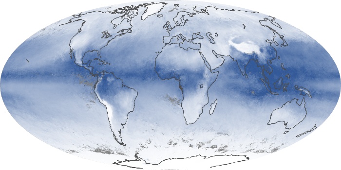
These maps show the average amount of water vapor in a column of atmosphere in a given month. The units are given in centimeters, which is the equivalent amount of water that could be produced if all the water vapor in the column were to condense. The lowest amounts of water vapor (0 centimeters) appear in yellow, and the highest amounts (6 centimeters) appear in dark blue. Areas of missing data appear in shades of gray. The maps are based on data collected by the Moderate Resolution Imaging Spectroradiometer (MODIS) sensor on NASA’s Aqua satellite.
The most noticeable pattern in the time series is the influence of seasonal temperature changes and incoming sunlight on water vapor. In the tropics, a band of extremely humid air wobbles north and south of the equator as the seasons change. This band of humidity is part of the Intertropical Convergence Zone, where the easterly trade winds from each hemisphere converge and produce near-daily thunderstorms and clouds. Farther from the equator, water vapor concentrations are high in the hemisphere experiencing summer and low in the one experiencing winter.
Another pattern that shows up in the time series is that water vapor amounts over land areas decrease more in winter months than adjacent ocean areas do. This is largely because air temperatures over land drop more in the winter than temperatures over the ocean. Water vapor condenses more rapidly in colder air.
- View, download, or analyze more of these data from NASA Earth Observations (NEO):
- Water Vapor


No hay comentarios:
Publicar un comentario