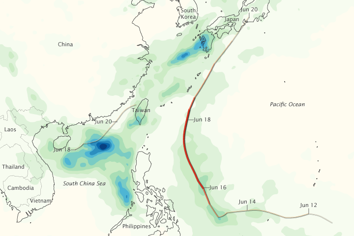
acquired June 13 - 19, 2012
Guchol and Talim brought rain as well
as wind to the western Pacific Ocean in June 2012. This image shows
rainfall totals in the region from June 13 to 19, 2012. The heaviest
rainfall—more than 600 millimeters, or 24 inches—appears in dark blue.
The lightest rainfall—less than 75 millimeters or 3 inches—appears in
light green. Trace amounts appear in pale yellow.
Superimposed on the rainfall amounts are storm tracks, with darker shades of red corresponding with stronger storms. Guchol traveled roughly northward, east of the Philippines, and Talim skirted the coast of southeastern China. The heaviest rainfall occurred west of the Philippines and Taiwan, and southwest of Japan. A band of moderately heavy rain also followed the track of Guchol.
Talim lasted as a tropical storm from June 18 to 20. Guchol strengthened to a tropical storm on June 12, to a typhoon on June 14, and to a super typhoon on June 16. It retained typhoon strength until June 19. The Mainichi reported that Guchol weakened after making landfall but still brought heavy rains and high winds to eastern and northeastern Japan.
This map is based on data from the Multisatellite Precipitation Analysis produced at NASA’s Goddard Space Flight Center, which estimates rainfall by combining measurements from many satellites and calibrating them using rainfall measurements from the Tropical Rainfall Measuring Mission (TRMM) satellite.
References
- The Mainichi. (2012, June 20) Typhoon weakens after hitting Japan, 1 killed, 1 missing. Accessed June 21, 2012.
- Unisys Weather. (2012, June 21) Guchol Tracking Information. Accessed June 21, 2012.
- Unisys Weather. (2012, June 21) Talim Tracking Information. Accessed June 21, 2012.
NASA Earth Observatory image by Jesse Allen, using data from the TRMM Science Data and Information System at Goddard Space Flight Center. Caption by Michon Scott.
- Instrument:
- TRMM - MPA
NASA: Philippines - China - Taiwan - Japan - Heavy Rains from Guchol and Talim - 21.06.12
Ricardo M Marcenaro - Facebook
Operative blogs of The Solitary Dog:
solitary dog sculptor:
http://byricardomarcenaro.blogspot.com
Solitary Dog Sculptor I:
http://byricardomarcenaroi.blogspot.com
Para:
comunicarse conmigo,
enviar materiales para publicar,
propuestas:
marcenaroescultor@gmail.com
For:
contact me,
submit materials for publication,
proposals:
marcenaroescultor@gmail.com
Diario La Nación
Argentina
Cuenta Comentarista en el Foro:
Capiscum
My blogs are an open house to all cultures, religions and countries. Be a follower if you like it, with this action you are building a new culture of tolerance, open mind and heart for peace, love and human respect.
Thanks :)
Mis blogs son una casa abierta a todas las culturas, religiones y países. Se un seguidor si quieres, con esta acción usted está construyendo una nueva cultura de la tolerancia, la mente y el corazón abiertos para la paz, el amor y el respeto humano.
Gracias :)

No hay comentarios:
Publicar un comentario