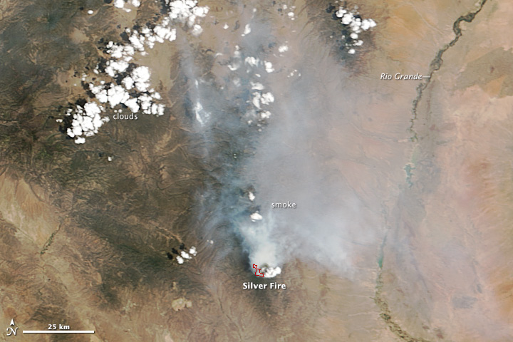
acquired June 10, 2013
download large image (1 MB, JPEG, 2000x1600)
acquired June 10, 2013
download GeoTIFF file (5 MB, TIFF)
acquired June 10, 2013
download Google Earth file (KMZ)
Extreme drought fueled wildfires in New Mexico during June 2013. With fires already burning in northern New Mexico, another intense fire emerged in the southern part of the state in Gila National Forest on June 7, 2013.
Lightning ignited the Silver Fire in a rugged, forested area east of of Silver City, New Mexico. On June 10, 2013, the Moderate Resolution Imaging Spectroradiometer (MODIS) on NASA’s Terra satellite captured this image of the fire. Red outlines indicate hot spots where MODIS detected unusually warm surface temperatures that are associated with fires.
According to firefighting agencies in New Mexico, the Silver Fire had spread across nearly 6,700 acres (2,700 hectares) by by the morning of June 11. The fires were being fought by 350 firefighters on the ground and by helicopters.
An assessment of wildfire vulnerability issued by the National Interagency Fire Center in early June pointed out that much of the New Mexico had received less than half the normal amount of rain in May. About 82 percent of the state was in either extreme or exceptional drought, according to the U.S. Drought Monitor. New Mexico will be at a high risk of wildfire throughout the hot and dry month of June, but wetter conditions should arrive in July when weather patterns shift and the North American monsoon brings more rain to the state.
References
- InciWeb (2013, June 11) Silver Fire. Accessed June 11, 2013.
- National Interagency Fire Center (2013, June 1) National Significant Wildland Fire Potential Outlook (pdf). Accessed June 11, 2013.
- NOAA North American Monsoon. Accessed June 11, 2013.
- U.S. Drought Monitor (2013, May 28) Drought Summary: New Mexico. Accessed June 11, 2013.
Further Reading
- Las Cruces Sun-News (2013, June 10) Kingston evacuated as crews battle Silver Fire. Accessed June 11, 2013.
- Silver City Sun-News (2013, June 10) Fire in Black Range closes Highway 152, forces evacuation of Kingston. Accessed June 11, 2013.
NASA image courtesy Jeff Schmaltz, LANCE/EOSDIS MODIS Rapid Response Team at NASA GSFC. Caption by Adam Voiland.
- Instrument:
- Terra - MODIS
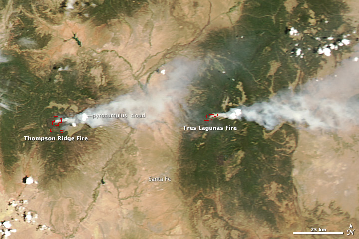
acquired June 11, 2013
download large image (4 MB, JPEG, 3400x4400)
On June 11, 2013, the Moderate Resolution Imaging Spectroradiometer (MODIS) on NASA’s Aqua satellite captured this image of the Tres Lagunas fire and Las Conchas fire
burning in New Mexico near Santa Fe. Red outlines indicate hot spots
where MODIS detected unusually warm surface temperatures associated with
fires. The light spots within the smoke plumes appear to be pyrocumulus clouds.
References
- InciWeb (2013, June 13) Las Conchas Fire. Accessed June 13, 2013.
- InciWeb (2013, June 13) Tres Lagunas Fire. Accessed June 13, 2013.
NASA image courtesy Jeff Schmaltz, LANCE MODIS Rapid Response Team at NASA GSFC. Caption by Adam Voiland.
- Instrument:
- Aqua - MODIS
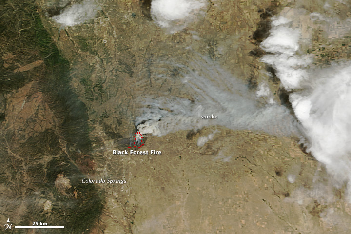
acquired June 12, 2013
download large image (5 MB, JPEG, 3800x4600)
acquired June 12, 2013
download GeoTIFF file (29 MB, TIFF)
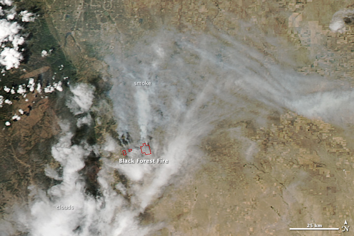
acquired June 12, 2013
download large image (6 MB, JPEG, 3800x4600)
acquired June 12, 2013
download GeoTIFF file (30 MB, TIFF)
acquired June 12, 2013
download Google Earth file (KMZ)
When the National Interagency Fire
Center released its 2013 wildfire outlook in early June, it did not
forecast unusually high fire risk for Colorado. Most of the Rockies
received some relief from drought during the spring, so there was hope
that this year’s fire season would be more manageable than the last.
But then the heat arrived. Temperatures soared above 100°F (38 °C) in Denver on June 11, the earliest it has ever reached triple digits. That heat, along with gusty winds and drought-parched forests, came together to produce the Black Forest fire, the most destructive the state has ever seen. By the afternoon of June 13, the fire had destroyed 360 homes and damaged 14 others. The Waldo Canyon fire, Colorado’s most destructive prior to the Black Forest fire, destroyed 346 homes.
The Black Forest fire began on June 11 in a densely-wooded area north of Colorado Springs, Colorado. On June 12, 2013, the Moderate Resolution Imaging Spectroradiometer (MODIS) on NASA’s Terra and Aqua satellites captured these images of the fire about 20 miles (30 kilometers) northeast of Colorado Springs. The Terra image (top) was collected at 12:05 p.m. Mountain Daylight Time, and the Aqua image (lower) was collected at 1:40 p.m. MDT. Red outlines indicate hot spots where MODIS detected the unusually warm surface temperatures associated with fires.
According to firefighting agencies in Colorado, the Black Forest fire had spread through 15,000 acres (6,000 hectares) by the afternoon of June 13. Hundreds of people on the ground and numerous water-dropping helicopters and planes were fighting the blaze, but it remained zero percent contained on the afternoon of June 13. More than 38,000 people had been forced to evacuate their homes. Tens of thousands more people coped with elevated air pollution levels because of the fires.
References
- NASA (2013, June 13) Western US Fires Flare Up. Accessed June 13, 2013.
- National Interagency Fire Center (2013, June 1) National Significant Wildland Fire Potential Outlook (pdf). Accessed May 3, 2013.
- Rocky Mountain Area Coordination Center (2013, June 12) Black Forest Fire Accessed June 3, 2013.
- U.S. Drought Monitor (2013, June 11) Colorado. Accessed June 13, 2013.
- Weather Underground (2013, June 12) Record head fuels destructive fires in drought-baked Colorado. Accessed June 13, 2013.
Further Reading
- Denver Post (2013, June 13) Colorado Wildfires: Live Updates. Accessed June 13, 2013.
- The Gazette (2013, June 13) Black Forest Fire: Live Updates. Accessed June 13, 2013.
- Yahoo (2013, June 13) Slideshow: Colorado Wildfires. Accessed June 13, 2013.
NASA image courtesy Jeff Schmaltz, LANCE MODIS Rapid Response Team at NASA GSFC. Caption by Adam Voiland.
- Instrument:
- Terra - MODIS
acquired June 11, 2013
download large image (4 MB, JPEG, 3400x4400)
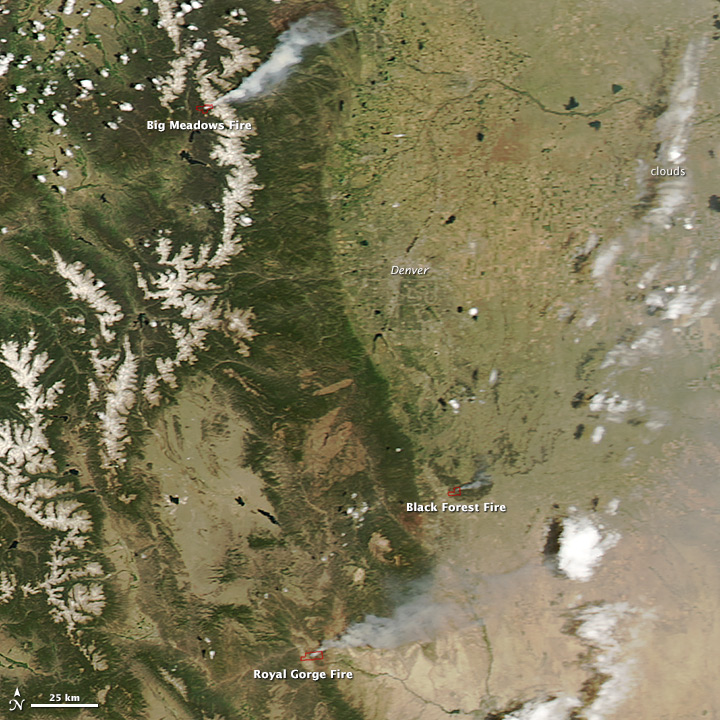
On June 11, 2013, the Moderate Resolution Imaging Spectroradiometer (MODIS) on NASA’s Aqua satellite captured this image of the Royal Gorge, Big Meadows, and Black Forest
fires burning in Colorado. Red outlines indicate hot spots where MODIS
detected unusually warm surface temperatures associated with fires.
References
- InciWeb (2013, June 13) Royal Gorge Fire. Accessed June 13, 2013.
- InciWeb (2013, June 13) Big Mountain Fire. Accessed June 13, 2013.
- Rocky Mountain Area Coordination Center (2013, June 13) Black Forest Fire. Accessed June 13, 2013.
NASA image courtesy Jeff Schmaltz, LANCE MODIS Rapid Response Team at NASA GSFC. Caption by Adam Voiland.
- Instrument:
- Aqua - MODIS
Ricardo M Marcenaro - Facebook
Blogs in operation of The Solitary Dog:
Solitary Dog Sculptor:
byricardomarcenaro.blogspot.com
Solitary Dog Sculptor I:
byricardomarcenaroi.blogspot.com/
Para:
comunicarse conmigo
comunicarse conmigo
marcenaroescultor@gmail.com
For:
contact me
For:
contact me
marcenaroescultor@gmail.com
My blogs are an open house to all cultures, religions and countries. Be a follower if you like it, with this action you are building a new culture of tolerance, open mind and heart for peace, love and human respect. Thanks :)
Mis blogs son una casa abierta a todas las culturas, religiones y países. Se un seguidor si quieres, con esta acción usted está construyendo una nueva cultura de la tolerancia, la mente y el corazón abiertos para la paz, el amor y el respeto humano. Gracias:)
(::)

No hay comentarios:
Publicar un comentario