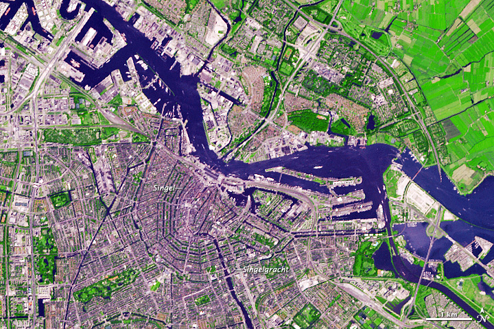
A network of canals encircles the
medieval city center of Amsterdam. Planned at the end of the sixteenth
century and built during the seventeenth, the city is a “masterpiece of
hydraulic engineering,” according to the United Nations Educational,
Scientific, and Cultural Organization (UNESCO). By draining swampland
and digging canals, Amsterdam’s designers created a port city that
inspired planners in England, Sweden, and especially Russia—where Peter
the Great hired Dutch engineers to transform swampy terrain into St.
Petersburg.
The Advanced Spaceborne Thermal Emission and Reflection Radiometer (ASTER) on NASA’s Terra
satellite acquired this image of Amsterdam on July 24, 2012. ASTER
combines infrared, red, and green wavelengths of light to make
false-color images. In this image, urbanized areas appear in shades of
gray; vegetation is red; and water is blue. The concentric canals appear
as blue semicircles spreading out from the historic city center.
Centuries before it took on its present configuration, Amsterdam was a
small fishing village on the banks of the Amstel River. People living
in the region constructed an earthen dam to hold back the sea; when a
bridge over the Amstel was connected to the dam, there was soon a route
for overland traffic. Deriving its name from “Amstel” and “dam,”
Amsterdam was declared a city in 1306.
Trade brought prosperity, and by the end of the sixteenth century,
Amsterdam was growing past its medieval defenses. City planners
undertook an ambitious project of swamp draining and canal digging to
extend the city. Once roughly confined to the area within the Singel,
the city was expanded outwards to the Singelgracht. After the concentric
canals were dug, smaller canals were added and stretched straight out
from the city center. The new, straight canals created dozens of
islands, now linked by hundreds of bridges. Today, residents and
tourists alike can easily navigate the city on its municipal canal-bus
system.
-
References
- A View on Cities Amsterdam’s Canals. Accessed March 21, 2013.
- World Heritage (2013) Seventeenth-century canal ring area of Amsterdam inside the Singelgracht. UNESCO. Accessed March 21, 2013.
NASA image created by Jesse Allen, using EO-1 ALI data provided courtesy of the NASA EO-1 team. Caption by Michon Scott.
- Instrument:
- Terra - ASTER
NASA: Netherland - Amsterdam - The Advanced Spaceborne Thermal Emission and Reflection Radiometer (ASTER) - 25.07.13
Ricardo M Marcenaro - Facebook
Blogs of The Solitary Dog:
Solitary Dog Sculptor:
http://byricardomarcenaro.blogspot.com
Solitary Dog Sculptor I:
http://byricardomarcenaroi.blogspot.com
Para:
comunicarse conmigo,
enviar materiales para publicar,
propuestas comerciales:
marcenaroescultor@gmail.com
For:
contact me,
submit materials for publication,
commercial proposals:
marcenaroescultor@gmail.com
Diario La Nación
Argentina
Cuenta Comentarista en el Foro:
Capiscum
My blogs are an open house to all cultures, religions and countries. Be a follower if you like it, with this action you are building a new culture of tolerance, open mind and heart for peace, love and human respect.
Thanks :)
Mis blogs son una casa abierta a todas las culturas, religiones y países. Se un seguidor si quieres, con esta acción usted está construyendo una nueva cultura de la tolerancia, la mente y el corazón abiertos para la paz, el amor y el respeto humano.
Gracias :)


No hay comentarios:
Publicar un comentario