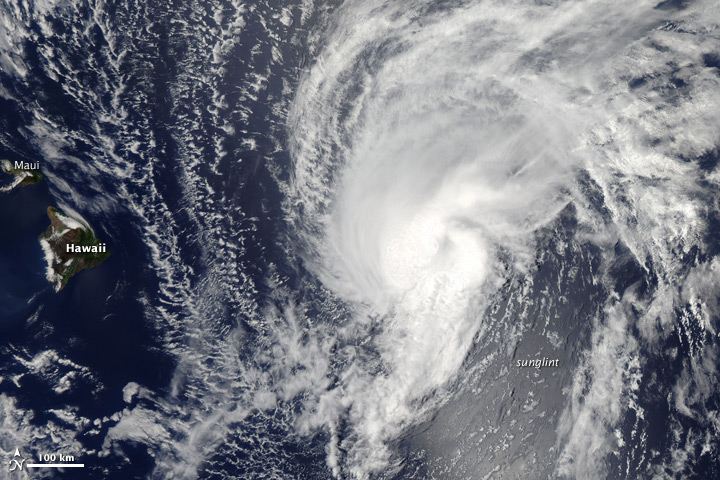
The Moderate Resolution Imaging Spectroradiometer (MODIS) on NASA’s Aqua
satellite acquired this image of Tropical Storm Flossie at 1:10 p.m.
local time (23:10 Universal Time) on July 28, 2013. The storm was moving
westward across the Pacific Ocean, headed for the Hawaiian Islands. It
is expected to be the first tropical storm to make landfall on the
islands in nearly 20 years.
According to Unisys Weather,
at 10 a.m. local time on July 28, the storm had winds of roughly 60
miles per hour (50 knots or 90 kilometers per hour) and a pressure of
996 millibars.
NASA image courtesy Jeff Schmaltz, LANCE/EOSDIS MODIS Rapid Response Team at NASA GSFC. Caption by Mike Carlowicz.
- Instrument:
- Aqua - MODIS
NASA: Pacific Ocean - Hawaii zone - Tropical Storm Flossie - 29.07.13
Ricardo Marcenaro
Argentina
Ricardo M Marcenaro - Facebook
Blogs in operation of The Solitary Dog:
Solitary Dog Sculptor:
byricardomarcenaro.blogspot.com
Solitary Dog Sculptor I:
byricardomarcenaroi.blogspot.com/
Para:
comunicarse conmigo,
enviar materiales para publicar,
propuestas comerciales:
comunicarse conmigo,
enviar materiales para publicar,
propuestas comerciales:
marcenaroescultor@gmail.com
For:
contact me,
submit materials for publication,
commercial proposals:
For:
contact me,
submit materials for publication,
commercial proposals:
marcenaroescultor@gmail.com
Diario La Nación
Argentina
Cuenta Comentarista en el Foro:
My blogs are an open house to all cultures, religions and countries. Be a follower if you like it, with this action you are building a new culture of tolerance, open mind and heart for peace, love and human respect. Thanks :)
Mis blogs son una casa abierta a todas las culturas, religiones y países. Se un seguidor si quieres, con esta acción usted está construyendo una nueva cultura de la tolerancia, la mente y el corazón abiertos para la paz, el amor y el respeto humano. Gracias:)
(::)


No hay comentarios:
Publicar un comentario